Madagascar Maps and Orientation
(Madagascar, MG, Africa)
Formerly known as the Malagasy Republic, the Republic of Madagascar is an African island nation and resides just off the country's south-easterly shoreline, being separated from
Mozambique by the Indian Ocean. The main island of Madagascar is huge, approximately 587,000 square kilometres / 226,650 square miles in size and ranking as the fourth-biggest island anywhere on the planet.
Other significant islands within the archipelago include Ile Sainte Marie / Nosy Boraha (close to Maintirano), Nosy Komba (north of Ambanja) and the major tourist resort of Nosy Be (nearby Andoany).
Maps and Orientation of the Country
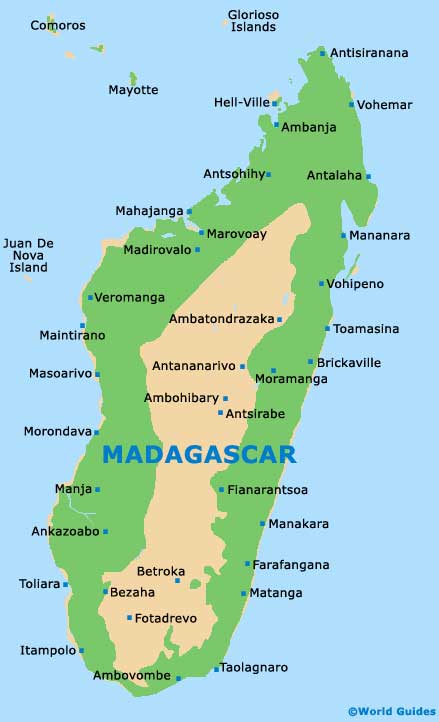
On the island of Madagascar itself are a number of notable cities and towns, clearly depicted on maps and spread around the six main regions of Antsiranana (north), Toamasina (east / north-east), Fianarantsoa (east / south-east), Mahajanga (west / north-west), Antananarivo (central) and Toliara (west / south-west).
The
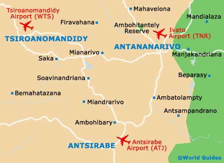
Montagne d'Ambre National Park (Amber Mountain National Park) lies within the Antsiranana Province, along with Andoany, while the Toamasina Province comprises Toamasina and Vatomandry, as well as the Ile aux Nattes. In Fianarantsoa, Ambositra and the Andringitra National Park are the most prominent destinations, with the Tsingy de Bemaraha Nature Reserve standing out in Mahajanga. The Antananarivo Province is where the capital city of Antananarivo is situated, accompanied by the Central Highlands' city of Antsirabe. Finally, in the Toliara Province is the traditional fishing village of Anakao, together with the Isalo National Park.
Continent Map of Africa

Map of Madagascar
Map of Antananarivo