Palm Springs Maps and Orientation
(Palm Springs, California - CA, USA)
The small desert city of Palm Springs resides on the southern side of California, part-way between
Anaheim and the Arizona state border, and within the Coachella Valley.
Palm Springs is to be found in Riverside County and is within reasonable driving distance of numerous tourist cities, such as
Los Angeles and
San Diego, both of which are in the region of three hours away by road. Various mountains surround the city, such as those of San Bernardino (north) and Santa Rosa (south), which offer much shelter and provide imposing backdrops.
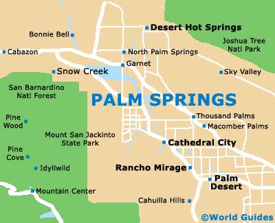
There are roughly 30 different neighborhoods within Palm Springs, although for tourists in the city, maps will show that much of the interest resides within the downtown district. Here you will find the Palm Springs Convention Center, the Ruth Hardy Park, the Spa Resort Casino and the Palm Springs Stadium, which stands on the corner of East Ramon Road and South Sunrise Way, and is used to stage important baseball games to crowds of up to 5,000 spectators.
Maps and Orientation of the City
The desert towns and cities of the Coachella Valley are easy to reach, thanks to the presence of Highway US-111 and the Christopher Columbus Transcontinental Highway (Interstate I-10), which is also known as the Sonny Bono Memorial Freeway.
Various spreading parks and preserves dominate the surrounding landscape. The Joshua Tree National Park lies to the east of Palm Springs, the Mount San Jacinto State Park to the west, the Anza-Borrego Desert State Wilderness to the south, and the San Bernardino National Forest to the northwest.
- Anaheim - 90 miles / 145 km (two hours and 20 minutes, west)
- Cathedral City - 7 miles / 11 km (15 minutes, south)
- Escondido - 105 miles / 169 km (two hours and 40 minutes, southwest)
- Hemet - 42 miles / 68 km (one hour, southwest)
- Hesperia - 88 miles / 142 km (two hours and 15 minutes, northwest)
- Joshua Tree National Park - 69 miles / 111 km (one hour and 45 minutes, east)
- Laguna Niguel - 106 miles / 171 km (two hours and 45 minutes, southwest)
- Los Angeles - 107 miles / 172 km (two hours and 50 minutes, west)
- Mission Viejo - 99 miles / 159 km (two hous and 25 minutes, southwest)
- Oceanside - 108 miles / 174 km (two hours and 45 minutes, southwest)
- Palm Desert - 14 miles / 23 km (25 minutes, southeast)
- Poway - 122 miles / 196 km (three hours, southwest)
- Riverside - 56 miles / 90 km (one hour and 25 minutes, west)
- San Bernardino - 55 miles / 89 km (one hour and 25 minutes, northwest)
- San Diego - 130 miles / 209 km (three hours and 15 minutes, southwest)
- San Marcos - 112 miles / 180 km (two hours and 50 minutes, southwest)
- Santa Ana - 93 miles / 150 km (two hours and 20 minutes, west)
- Santa Monica - 121 miles / 195 km (three hours, west)
- Temecula - 81 miles / 130 km (two hours, southwest)
Map of the United States
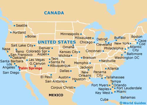
Map of California

Map of Palm Springs