San Juan Maps and Orientation
(San Juan, Puerto Rico)
The capital city of
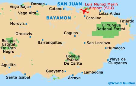
Puerto Rico, San Juan lies on the north-east of the island along San Juan Bay, and occupies 200 square kilometres / 77 square miles in total, including two natural lagoons, Condado and San Jose. South of the city is Caguas, to the west is Guaynabo and to the east is Carolina.
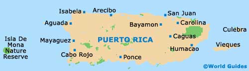
The island's topography is mountainous, with a fertile coastal plain to the north holding many sandy beaches. Apart from in the main cities, transportation across Puerto Rico is poor and there are no scheduled buses or trains. Several major highways and three fast toll roads are useful, but local roads need care.
Maps and Orientation of the City / Metropolitan Area
San Juan has clearly-defined districts, with Old San Juan based at its heart and home to the majority of the attractions. Upscale residential Condado includes the beach resort area, and nearby Miramar has expensive and historic houses.
Isla Verde, closer to neighbouring Carolina City, features good beaches and parks, while Hato Rey serves as the central business district, home to a massive mall as well as banks. Rio Pedras hosts the University of Puerto Rico and the Santurce district is the cultural capital of the island.
- Aguada - 140 km / 87 miles (two hours and 15 minutes, west)
- Arecibo - 81 km / 51 miles (one hour and 15 minutes, west)
- Bayamon - 18 km / 11 miles (25 minutes, south-west)
- Caguas - 32 km / 20 miles (30 minutes, south)
- Carolina - 21 km / 13 miles (25 minutes, south-east)
- Fajardo - 60 km / 37 miles (one hour and five minutes, south-east)
- Guaynabo - 15 km / 9 miles (15 minutes, south)
- Isabela - 117 km / 73 miles (one hour and 55 minutes, west)
- Las Croabas - 64 km / 40 miles (one hour and five minutes, east)
- Mayaguez - 192 km / 120 miles (two hours and 50 minutes south-west)
- Ponce - 117 km / 73 miles (one hour and 55 minutes, south-west)
- Vega Baja - 43 km / 27 miles (40 minutes, west)
Map of Puerto Rico
Map of San Juan