Santiago de Cuba Maps and Orientation
(Santiago de Cuba, Cuba)
The city of Santiago de Cuba lies on an almost enclosed bay, on the eastern Caribbean coast of the island of
Cuba. Crowded onto a coastal terrace overlooked by the mountains of the Sierra Maestra, the city streets wind up and down the hilly terrain.
Santiago de Cuba is surrounded by areas of natural beauty, national parks, sugar cane plantations and a UNESCO biosphere reserve, and has miles of beaches stretching north along the Caribbean coastline towards the Granma province. The city links to the central and northern regions of Cuba via the Central Highway, and to Baracoa and Guantanamo in the far south-east of the island via a modern road across high mountains. However, roads, apart from the main highways, are very poor. Good maps are hard to come by in Cuba, but can be found online either to download or buy, and are essential if travelling by car.
Maps and Orientation of the City
The historic centre of Santiago de Cuba, a UNESCO World Heritage site, lies close to the coastline and was planned along the exact lines of the ancient village it replaced. Most of the cultural attractions lie in this area of the city, being convenient for hotels and other lodging options, and can be seen on foot.
The fascinating and hilly French-Haitian El Tivoli district lies to the south of Parque Cespedes, where it boasts winding cobbled streets and charming old houses. Several attractive public parks serve as the city's green lungs, and the broad boulevard which runs down and along the harbourfront is a good place for an evening stroll. Of note, maps showing the main city attractions should be available at upscale hotels and car rental offices.
- Baracoa - 240 km / 150 miles (four hours, east)
- Camaguey - 327 km / 204 miles (five hours and 30 minutes, north-west)
- Chivirico - 70 km / 43 miles (one hour and five minutes, south-west)
- El Cobre - 20 km / 12 miles (25 minutes, north-west)
- Granjitar Siboney - 15 km / 9 miles (20 minutes, south-east)
- Guantanamo - 90 km / 56 miles (one hour and 20 minutes, east)
- Havana - 897 km / 560 miles (14 hours and 30 minutes, north-west)
- Holguin - 135 km / 84 miles (two hours and 40 minutes, north)
- La Gran Piedra - 25 km / 16 miles (30 minutes, west)
- Matanzas - 832 km / 520 miles (14 hours, north-west)
- Sancti Spiritos - 522 km / 326 miles (nine hours and 30 minutes, north-west)
- Santa Clara - 607 km / 379 miles (10 hours, north-west)
- Varadero - 767 km / 479 miles (13 hours, north)
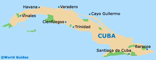
Map of Cuba
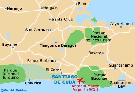
Map of Santiago de Cuba