Aix en Provence Maps and Orientation
(Aix en Provence, Provence-Alpes-Cote d'Azur, France)
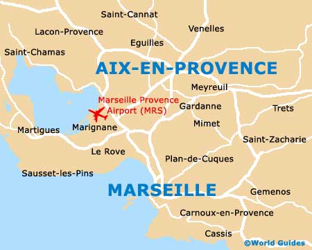
Located on the far south-eastern side of France and close to the Mediterranean coastline, Aix en Provence is an attractive city. Famed for its plentiful sunshine and proximity to Marseille, Aix en Provence is also within easy reach of Monaco and within driving distance of northern Italy.
Within the city proper, the Cours Mirabeau stretches between both the Place Forbin and the Place du Général de Gaulle, which is a large roundabout with a dramatic and historic fountain centrepiece, often known simply as La Rotonde. Situated on the northern side of the Cours Mirabeau is the Old Town area of Aix en Provence, Vieil Aix.
Maps and Orientation of the City
Nearby, the Avenue des Belges extends in a south-westerly directly and links the bus station. Also close to the famous fountain and roundabout, the Avenue Victor Hugo connects the south-easterly train station, while the Mazarin Quarter lies directly south.
Central Aix en Provence is surrounded by a number of one-way streets and boulevards, which can make driving around quite frustrating and problematic. A map is always advisable for those intending to navigate this part of the city and beyond.
- Bouc-Bel-Air - 11 km / 7 miles (12 minutes, south)
- Cabries - 14 km / 9 miles (14 minutes, south-west)
- Eguilles - 10 km / 6 miles (10 minutes, north-west)
- Fuveau - 18 km / 11 miles (16 minutes, south-east)
- Gardanne - 14 km / 9 miles (15 minutes, south)
- Lambesc - 21 km / 13 miles (17 minutes, north-west)
- Marignane - 32 km / 20 miles (25 minutes, south-west)
- Plan de Cuques - 37 km / 23 miles (30 minutes, south)
- Salon de Provence - 35 km / 22 miles (30 minutes, north-west)
- Velaux - 24 km / 15 miles (20 minutes, west)
- Venelles - 10 km / 6 miles (10 minutes, north)
- Vitrolles - 32 km / 20 miles (25 minutes, south-west)
Map of France

Map of Aix en Provence