Kuching Maps and Orientation
(Kuching, Sarawak, Malaysia)
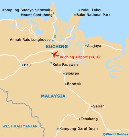
Kuching lies along the Sarawak River in the north-east of Malaysian Borneo, and is the Sarawak State's capital. The river divides the city north to south and the metropolitan boundaries extend from the airport, south of the city, to the northern peninsular coasts of Baku and Santubong, to the western Kuching National Park, and to the eastern Kuap River's estuary.
Kuching has one of the largest urban areas in the country, with a population of more than 650,000. Off the main roads around the city, a map is necessary as signposting, if it exists, may be confusing. Drivers' maps of Sarawak can be downloaded, or obtained from your car hire office or from the tourist office in the old courthouse.
Maps and Orientation of the City
Kuching is divided into number of districts, most of which were villages surrounding the original town, now swallowed up by its expansion. New housing and commercial districts are under construction as a response to steadily increasing demand. The Padungan district is the oldest and contains the waterfront, most of the major hotels, tourist attractions, shopping facilities and Chinatown.
The nearest beaches are some 30 km / 19 miles away at Santubong, and the Padawan district on the edge of the city has traditional longhouses and multi-racial communities, including both Iban and Orang Ulu. Visitors generally find that the city centre is quite walkable.
- Bako National Park - 28 km / 18 miles (40 minutes, north-east)
- Bau - 26 km / 16 miles (35 minutes, south-west)
- Kampung Budaya Sarawak - 37 km / 23 miles (45 minutes, north)
- Kota Padawan - 13 km / 8 miles (20 minutes, south)
- Mount Santubong - 36 km / 22 miles (45 minutes, north)
- Mukah - 463 km / 289 miles (six hours and 40 minutes, north-east)
- Sematan - 102 km / 63 miles (one hour and 40 minutes, north-west)
- Serian - 65 km / 40 miles (one hour and ten minutes, south-east)
- Sibu - 410 km / 250 miles (six hours, north-east)
- Sri Aman - 187 km / 117 miles (two hours and 45 minutes, east)
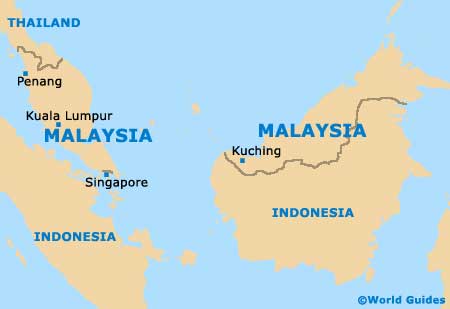
Map of Malaysia
Map of Kuching