Hartford Maps and Orientation
(Hartford, Connecticut - CT, USA)
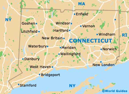
The state of Connecticut resides close to the far northeasterly tip of North America, with Hartford being the proud state capital. However, Hartford is not actually the state's biggest city and is only the third-biggest in terms of population (130,000), after both Bridgeport (the largest - 150,000) and New Haven (the second-largest - 135,000).
Downtown Hartford is separated from East Hartford by the Connecticut River, while surrounding towns bounding the state capital include Bloomfield, Newington, Wethersfield and Windsor.
A number of major highways connect the city with the rest of Connecticut, such as Interstate I-91 (Wilbur Cross Highway), which runs roughly north to south. Interstate I-84 heads in an east to west direction through the city center, before changing direction and leading northeastwards to Vernon and southwestwards to Southington.
Maps and Orientation of the City
The various neighborhoods and districts of Hartford offer different aspects to the city, with some of the most interesting being especially historic in character. Maps of downtown Hartford generally show the principal attractions, such as the Connecticut State Capital and the Old State House, as well as the main streets making up the city's Central Business District.
Close to downtown is the neighborhood of Frog Hollow, home of both Trinity College and Pope Park, while Parkville earned its name due to its setting alongside the tributaries of the Park River. Asylum Hill contains a mixture of residential properties and important headquarters for insurance and financial companies. This is also where you will find a taste of real history in the former homes of Harriet Beecher Stowe and Mark Twain.
Based in the city's West End is Elizabeth Park and the Governor's Residence, with South End being known for its Italian character and plentiful eateries. South Meadows is the location of the busy Hartford Brainard Airport.
- Agawam, Massachusetts (MA) - north
- Bloomfield - north
- Bridgeport - southwest
- Boston, Massachusetts (MA) - northeast
- Cromwell - south
- East Hartford - east
- Middletown - south
- New Haven - southwest
- Newington - south
- Southington - southwest
- Springfield, Massachusetts (MA) - north
- Vernon - northeast
- Waterbury - southwest
- Wethersfield - south
- Windsor - north
Map of USA
Map of Connecticut

Map of Hartford
